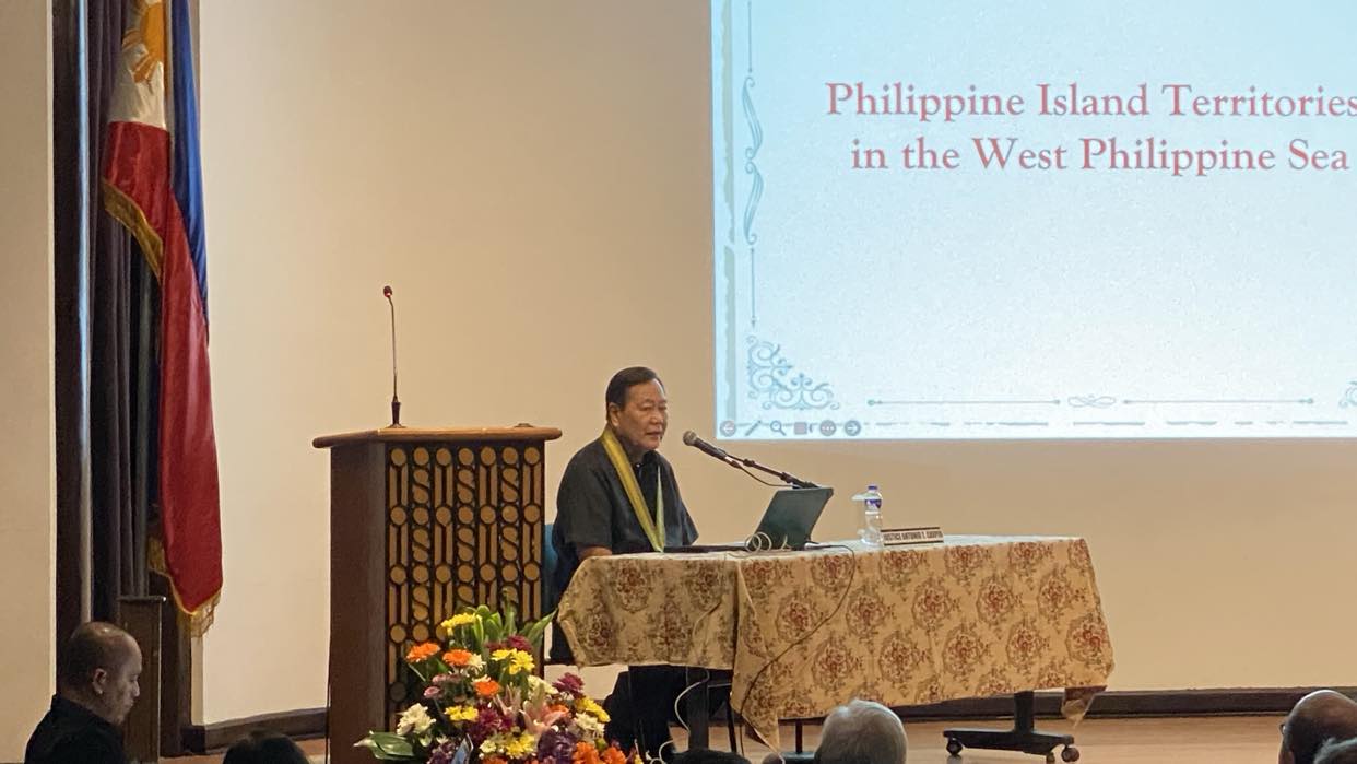
EVIDENCE OF claims over disputed islands in the South China Sea should be presented to the “court of world opinion” to debunk falsehoods about the longstanding dispute, former associate justice Antonio Carpio said.
If claimants like China refuse to subject their claims to formal arbitration, proof such as the 1900 Treaty of Washington and an 1875 map should be widely disseminated as an alternative, Carpio suggested during his lecture on Saturday, April 27, at the Thomas Aquinas Research Complex auditorium.
“If China, Vietnam and Malaysia do not want to submit to arbitration, they don’t want to go to the International Court of Justice, we go to the court of world opinion. We publicize all our evidence [on] why we have sovereignty over the Spratlys and Scarborough Shoal and we would put on the right side, ‘China please submit evidence here for the world to know,’” Carpio said.
“The UN (United Nations) Charter says all disputes must be settled by peaceful means through negotiations, mediation and finally by arbitration. The use of threat of force is outlawed, we will follow that,” he added.
The Spratly Islands have been the subject of a longstanding dispute among nearby nations due to its “maritime features” that provide tactical and economic advantages.
Vietnam and Malaysia have maintained their claim over the islands based on legal and historical grounds. China has asserted its maritime claim over virtually the entire South China Sea, including the Scarborough (Panatag) Shoal, through its so-called nine-dash line, which appeared on a Chinese map in 1947. An international arbitral court based in Hague voided China’s expansive claim in 2016.
Carpio presented the map used in the Treaty of Paris in 1898 wherein Scarborough Shoal and the Kalayaan Island Group, which is part of the Spratlys, lay outside the Philippine territory line.
“We have Filipino public intellectuals including our legal luminaries who have repeatedly stated that Philippine territory is limited to the islands within the lines of the 1898 treaty of Paris…I will establish here that this is factually, legally, and historically false. This has misled our people and the rest of the world as to the extent of Philippine territory,” he said.
The former high court justice called the limitation of the Paris lines “the greatest misconception in Philippine history,” as it was later amended by the United States in the 1900 Treaty of Washinton, where Spain ceded “any and all islands belonging to the Philippine archipelago lying outside the lines.”
Despite the amendment, the Treaty of Paris map has been instilled in Filipino minds, according to Carpio.
“We have to make it clear, because all that’s shown [on] the internet are this, that’s the famous Treaty of Paris lines. All the schoolchildren say it, ‘That’s Philippine territory,’” Caprio remarked.
Carpio also presented the official Philippine map from the Spanish regime issued in the 1900 treaty, the 1875 Carta General del Archipelago Filipino. He said the Philippines needs to acquire a copy of the map for it to be shown alongside the Pedro Murillo Velarde map from 1734, which aided the country’s case in the 2016 West Philippine Sea arbitration as it featured part of the Scarborough shoal and the Spratly islands.
In 2016, the Permanent Court of Arbitration ruled in favor of the Philippines, deeming historic claims through the nine-dash line as without legal basis, a ruling that China has ignored to this day.
The arbitral court also classified Scarborough Shoal and the Spratlys as not legally islands because of their inability to sustain human life.
Carpio, one of the experts who argued the Philippines’ case during the arbitration proceedings, noted that the title to uninhabitable islands is awarded to the country that first declares it as territory.
“You do not have to exercise continuous and peaceful show of sovereignty, because nobody is there to sign a treaty with you…Our title became complete already as of 1734,” he said, referring to the Velarde map.
Carpio also pointed out that several Chinese ancient maps dating back hundreds of years showed no traces of the disputed islands.
“In all their dynasty maps, the southernmost territory of China is Hainan…So China produced this atlas of ancient maps and none of those maps showed that the Paracels and the Spratlys and the Scarborough Shoal as part of Chinese territory. They are bound by that map they can’t get out of that,” he said.
President Ferdinand Marcos, Jr., who has been critical of China’s incursions in the South China Sea, has declared that he won’t surrender even an inch of Philippine territory to foreign aggressors. He has also promised to push back against attempts by China to ignore or question the Philippines’ sovereignty, sovereign rights and jurisdiction in the West Philippine Sea, the area in the South China Sea inside Manila’s exclusive economic zone and continental shelf.